
A top secret Soviet town for testing biological weapons stands abandoned in the middle of a desert in Central Asia.
It existed for more than 40 years on the godforsaken island in the Aral Sea and at first glance appeared to be a regular residential town with apartment buildings, shops, a school and a post office. But there was a test site too. Extensive experiments with deadly biological agents, like anthrax, plague, tularemia, brucellosis were made there on a regular basis.
Today, it lies abandoned. People left the town in the early 1990s after the collapse of the Soviet Union, and now it is but a ghost haunting the sands around the Aral Sea.
Here is a satellite view of the town of Kantubek located on what was once Vozrozhdeniya Island (also known as Renaissance or Rebirth Island).

Google Earth view of Kantubek
In fact, the Island no longer exists. It became part of the mainland in the tragedy of the Aral Sea that used to be the fourth largest lake in the world and therefore was called a "sea". Human actions can have a dramatic impact on the environment.
After the WWII the Soviets decided to build a test site for biological weapons in a hard-to-access place far from the borders with the potential enemies and far from Moscow.
Vozrozhdeniya Island was a perfect place for that. This desolate piece of land in the Aral Sea stood far away from civilization. The town in the salt lake on the border between Kazakhstan and Uzbekistan became a top secret Soviet base-polygon for testing deadly biological weapons in late 1940’s.
The island was about 200 square kilometers, uninhabited, with flat terrain and hot climate unsuitable for survival of pathogenic organisms.
Fifteen hundred inhabitants were brought to the island to run the project. It is unlikely that the garrison life in combination with harsh climate, constant proximity to deadly weapons and isolation were easy to bear. But the people lived on. Children went to school, their parents – to work. In the evenings, people gathered to watch a movie, on the weekends they had picnics on the shore of the Aral Sea.
This shore is now kilometers away from where it used to be back then. All because at the same time as the tests on Vozrozhdeniya Island were launched, the Soviet leadership began tampering with the area's water flows laying the foundation for a tragic ecological disaster involving the Aral Sea.

Infrared image of the Aral Sea made from space ©RIA Novosti
Two largest rivers in Central Asia - Amudarya and Syrdarya - have always been the main sources of water for the Aral Sea. But in 1960s the two rivers started to be extensively used for melioration because the Soviets decided to transform the surrounding desert into cotton fields. As cotton yields grew, the Aral Sea shrank.

Kazakh villagers collect metal parts of ruined ships in places that previously formed Aral seabed. ©REUTERS/Shamil Zhumatov
In the early 1970s, the amount of river water reaching the sea reduced by one third.
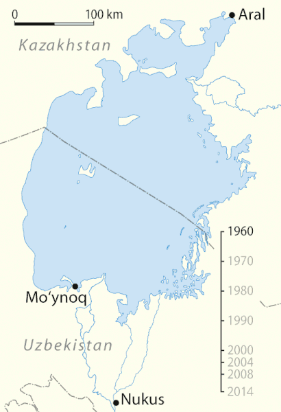
In the late 1980s, the water level in the sea dropped to low that it became divided into two parts: Northern "Small" Aral and Southern "Big" Aral.
The deteriorating state of the Aral Sea was kept hidden from the public in the Soviet Union for years until Gorbachev’s Glasnost allowed the information about the ecological disaster to seep through.
Transformation of the Aral Sea from 1960 to 2008 ©Wikimedia Commons
Nevertheless, to this day intensive irrigation of cotton and rice fields takes up a large part of the water flow of the two rivers. Precipitation in the form of rain and snow together with underground waters are not enough to compensate for evaporation, which means that the water volume of the sea decreases while its salinity increases.
Currently, the Aral Sea is only 10 percent of what it was about 50 years ago.
There was so little water in the Aral Sea that Vozrozhdeniya island and many others finally merged together and became part of the mainland in the 2000s. Now, it is a peninsula.
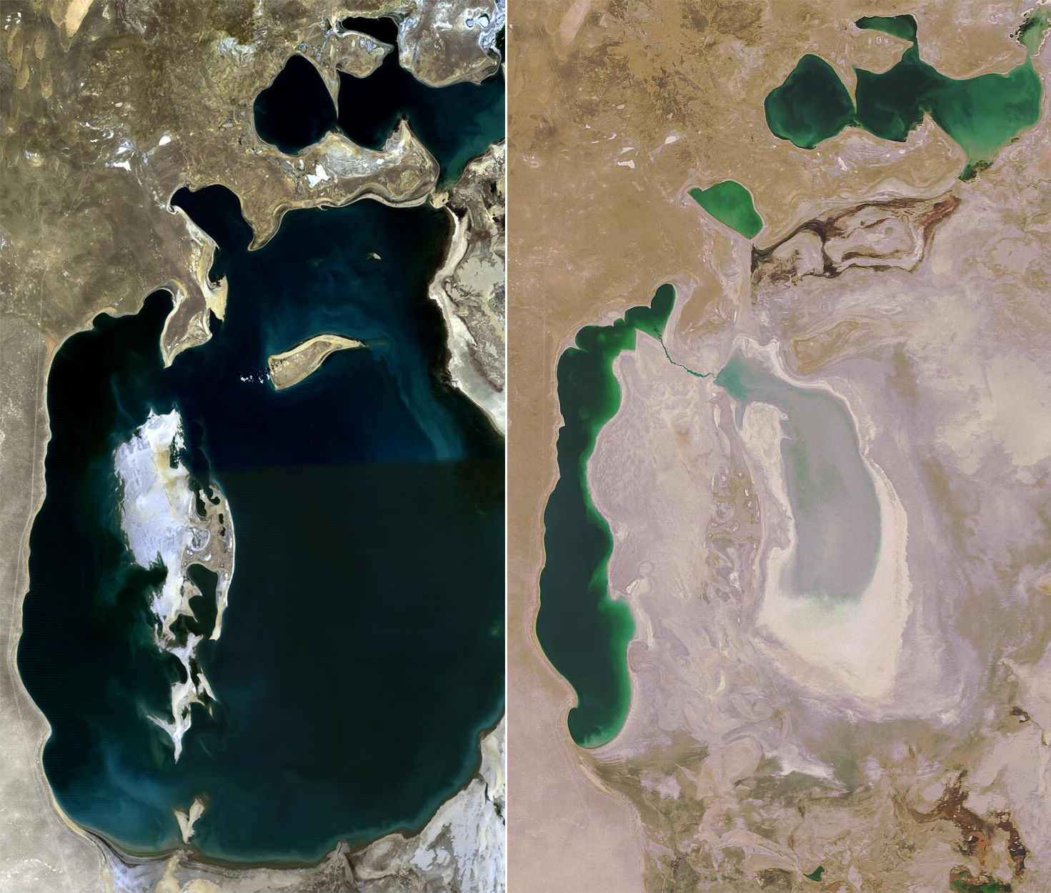
The Aral Sea before and in 2008 ©Wikimedia Commons
The Aral Sea was on the brink. Many species lost their habitat. In places where water backed out, a barren scenery of salt and sand stretches for kilometers, as far as one’s eyes can reach.
.jpg)
The bird died from inhaling salt dust ©RIA Novosti/Alexei Boitsov
Drainage water from the fields flowing back into the Syrdarya and Amudarya rivers caused sediments of pesticides and various other agricultural chemicals to appear on the area of 50 thousand square kilometers of the former sea bottom.
Dust storms pick up and spread salt, dust and chemicals as far as 500 kilometers around. Sodium bicarbonate, sodium chloride and sodium sulcate are destroying or slowing down emergence of natural vegetation and crops.

Dry and saline soil near of the Aral Sea ©REUTERS
The number of fish species decreased from 32 to 6 as a result of growing salinity, loss of spawning grounds and foraging areas. In the 1960’s the yearly fish catch would reach 40,000 tons. By mid-1980s the local fishing industry simply ceased to exist, leading to loss of tens of thousands of jobs.
Shipping in the Aral Sea stopped as the water receded many kilometers from the area's major ports - the city of Aralsk in the north and the city of Minak in the south.
.jpg)
A Kazakh fisherman walks back with his humble catch in south-western Kazakhstan ©REUTERS/Shamil Zhumatov
The local population suffers from high rates of respiratory diseases, anemia, larynx and esophagus cancer, as well as digestive disorders. Liver, kidney and eye diseases have become common in the area.
The degradation of the Aral Sea is a tragedy, but is it possible to save the Sea?
This task requires quadrupling the annual inflow of Amudarya and Syrdarya waters as compared to the current average of 13 cubic km. The only possible way of doing this is to reduce irrigation that takes up more than 90% of water from these rivers. However, four (Kyrgyzstan, Tajikistan, Turkmenistan, Uzbekistan) out of five Central Asian nations in the Aral Sea basin (except Kazakhstan) do not intend to decrease farmland irrigation, citing the need to feed their growing populations.
Switching to less “thirsty” crops, for example from cotton to winter wheat, can help achieving this goal but two major water-using countries in the region - Uzbekistan and Turkmenistan - are planning to continue pursuing cotton industry for export purposes.
Another way is to significantly improve the existing irrigation channels: many of them are ordinary trenches that allow precious water to simply seep into the sand in huge amounts before it even reaches the fields. Modernization of the entire irrigation system could help save about 12 cubic km of water a year, but it would cost $16 billion.
Against all odds there is still hope that not all has been irreversibly lost. Kazakhstan took the task of saving the North Aral Sea through a project funded by the World Bank. The first phase of “Syr Darya Control & Northern Aral Sea” envisioned construction of a dam to separate the smaller northern part located at Kazakhstan's territory from the Uzbek southern part of the Aral Sea. The Kok-Aral Dam was built in 2005 and served to keep the water from Kazakhstan's rivers in the northern part of the sea. As a result, the level of water in the Northern Aral Sea increased by 24 meters by 2008. The maximum depth of the North Aral Sea reached 42 m in 2008. Salinity dropped by almost a half, allowing fish to be reintroduced. Around 3,000 tons of fish were caught in 2009 as opposed to 52 tons in 2004. Besides, there was enough water to supply all the irrigated lands.
Unfortunately, the second phase of the project has been dropped for now. Financing of the second phase requires even more money, so the project was postponed for an unspecified time.
A worrying fact accompanying the good news is that the bigger Southern Aral continues to dwindle. The dam allows Northern Sea to grow but prevents water from reaching Southern Aral. Moreover, Uzbekistan has not decreased its drainage of water for the cotton industry, which adds to the burden of Southern Aral.
So what is to be done?

©REUTERS
Sceptics say that the Aral Sea had been receding on several occasions in its history. And this is true. This does not mean, however, that the situation should be left to itself. Because this time it is not part natural cycles, but a result of direct human interference with nature.
By Dinara Urazova